
Make a donation
Gear up for your next adventure:
As an Amazon Associate, this site earns from qualifying purchases at no extra cost to you.
Bentonville topographic map
Click on the map to display elevation.
Make a donation
Gear up for your next adventure:
As an Amazon Associate, this site earns from qualifying purchases at no extra cost to you.
About this map
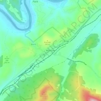
Name: Bentonville topographic map, elevation, terrain.
Location: Bentonville, Warren County, Virginia, 22610, United States (38.81142 -78.33682 38.85142 -78.29682)
Average elevation: 781 ft
Minimum elevation: 525 ft
Maximum elevation: 1,417 ft
Warren County trails, hiking, mountain biking, running and outdoor activities
Make a donation
Gear up for your next adventure:
As an Amazon Associate, this site earns from qualifying purchases at no extra cost to you.
Other topographic maps
Click on a map to view its topography, its elevation and its terrain.
Front Royal
United States > Virginia > Warren County
Front Royal, located in Warren County, Virginia, sits at an elevation of approximately 570 feet (174 meters) above sea level. It lies in a diverse topographic region, with the town nestled at the confluence of the North and South Forks of the Shenandoah River, which contributes to its distinctive river…
Average elevation: 636 ft
Shenandoah Farms
United States > Virginia > Warren County > Shenandoah Farms
Average elevation: 820 ft
Skyland Estates
United States > Virginia > Warren County > Skyland Estates
Average elevation: 1,198 ft
Make a donation
Gear up for your next adventure:
As an Amazon Associate, this site earns from qualifying purchases at no extra cost to you.