
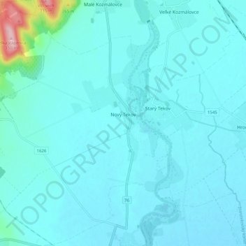
Nový Tekov topographic map
Interactive map
Click on the map to display elevation.
About this map
Name: Nový Tekov topographic map, elevation, terrain.
Average elevation: 577 ft
Minimum elevation: 522 ft
Maximum elevation: 1,132 ft
The village lies at an altitude of 171 metres and covers an area of 29.701 km². It has a population of about 830 people.
Other topographic maps
Click on a map to view its topography, its elevation and its terrain.
Pukanec
Slovakia > Region of Nitra > District of Levice
Pukanec, District of Levice, Region of Nitra, Western Slovakia, 935 05, Slovakia
Average elevation: 1,516 ft
Veľký Ďur
Slovakia > Region of Nitra > District of Levice
Veľký Ďur, District of Levice, Region of Nitra, Western Slovakia, 935 34, Slovakia
Average elevation: 630 ft