
Friesach topographic map
Click on the map to display elevation.
Friesach
Friesach covers an area of 120.83 km2 and its mean elevation is 631 meters above sea level. It is located in northern Carinthia near the border with Styria, about 40 km (25 mi) north of its capital Klagenfurt.
About this map
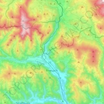
Name: Friesach topographic map, elevation, terrain.
Average elevation: 3,425 ft
Minimum elevation: 1,959 ft
Maximum elevation: 6,381 ft
Other topographic maps
Click on a map to view its topography, its elevation and its terrain.
Burg Hochosterwitz
Austria > Carinthia > Bezirk Sankt Veit an der Glan > Launsdorf > Hochosterwitz
Average elevation: 1,864 ft
Meiselding
Austria > Carinthia > Bezirk Sankt Veit an der Glan > Meiselding
Average elevation: 2,192 ft