
Make a donation
Gear up for your next adventure:
As an Amazon Associate, this site earns from qualifying purchases at no extra cost to you.
Uster topographic map
Click on the map to display elevation.
Make a donation
Gear up for your next adventure:
As an Amazon Associate, this site earns from qualifying purchases at no extra cost to you.
Uster
La ville d'Uster, principal centre industriel de l’Oberland zurichois, est située au bord du lac de Greifen, à une altitude de 464 mètres. Elle englobe le territoire de onze communes autrefois indépendantes.
Make a donation
Gear up for your next adventure:
As an Amazon Associate, this site earns from qualifying purchases at no extra cost to you.
About this map
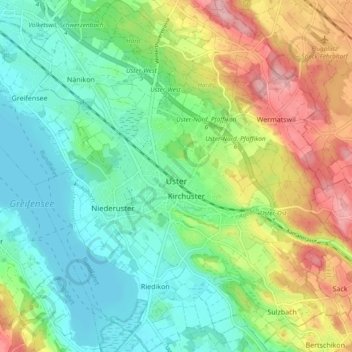
Name: Uster topographic map, elevation, terrain.
Location: Uster, Bezirk Uster, Zurich, Suisse (47.32015 8.67750 47.38387 8.76042)
Average elevation: 1,598 ft
Minimum elevation: 1,417 ft
Maximum elevation: 1,939 ft
Make a donation
Gear up for your next adventure:
As an Amazon Associate, this site earns from qualifying purchases at no extra cost to you.
Other topographic maps
Click on a map to view its topography, its elevation and its terrain.