Geolocate

Hamilton topographic map

Click on the map to display elevation.

About this map

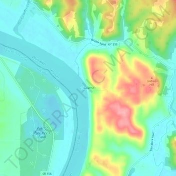
Name: Hamilton topographic map, elevation, terrain.

Location: Hamilton, Boone County, Kentucky, United States (38.86340 -84.80161 38.90340 -84.76161)

Average elevation: 554 ft

Minimum elevation: 440 ft

Maximum elevation: 814 ft

Boone County trails, hiking, mountain biking, running and outdoor activities

Other topographic maps

Click on a map to view its topography, its elevation and its terrain.

Burlington

United States > Kentucky > Boone County

Average elevation: 820 ft

Walton

United States > Kentucky > Boone County

Average elevation: 866 ft

Walton

United States > Kentucky > Boone County

Average elevation: 866 ft

Gear up for your next adventure:

🔭Telescopic Hiking Pole - Adjustable pole for hiking stability
🗻Climbing Gear Basics - Essential gear for beginner climbers
🪶Camping Sleeping Pad - Comfortable sleeping pad for backpacking
🔦Powerful Headlamps - Ultra-bright hands-free lighting for night navigation
📱Heavy-Duty Phone Cases - Drop-proof and waterproof protection for outdoor navigation

As an Amazon Associate, this site earns from qualifying purchases at no extra cost to you.