Geolocate

Ironton topographic map

Click on the map to display elevation.

About this map

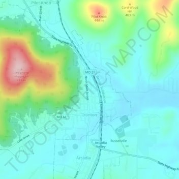
Name: Ironton topographic map, elevation, terrain.

Location: Ironton, Iron County, Missouri, 63650, United States (37.58789 -90.66428 37.61742 -90.61618)

Average elevation: 1,033 ft

Minimum elevation: 866 ft

Maximum elevation: 1,588 ft

Other topographic maps

Click on a map to view its topography, its elevation and its terrain.

Belleview

United States > Missouri > Iron County

Average elevation: 1,076 ft

Russellville

United States > Missouri > Iron County > Arcadia

Average elevation: 981 ft

Gear up for your next adventure:

📷Action Cameras - Rugged cameras to document your journeys across rugged terrain
🦶Hiking Gaiters - Keep debris and water out of your boots
🧭Pro Hiking Compasses - High-accuracy liquid-filled compasses for topographic orientation
📦Gear Storage Bags - Organize and protect outdoor equipment
🪶Multi‑Purpose Knife - Useful blade for camp and trail

As an Amazon Associate, this site earns from qualifying purchases at no extra cost to you.