
Make a donation
Gear up for your next adventure:
As an Amazon Associate, this site earns from qualifying purchases at no extra cost to you.
Davis topographic map
Click on the map to display elevation.
Make a donation
Gear up for your next adventure:
As an Amazon Associate, this site earns from qualifying purchases at no extra cost to you.
Davis
At an elevation of 3,520 feet, Davis has the highest elevation of any West Virginia town.
Make a donation
Gear up for your next adventure:
As an Amazon Associate, this site earns from qualifying purchases at no extra cost to you.
About this map
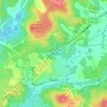
Name: Davis topographic map, elevation, terrain.
Location: Davis, Tucker County, West Virginia, United States (39.10854 -79.48071 39.14891 -79.43788)
Average elevation: 3,159 ft
Minimum elevation: 2,812 ft
Maximum elevation: 3,652 ft
Tucker County trails, hiking, mountain biking, running and outdoor activities
Make a donation
Gear up for your next adventure:
As an Amazon Associate, this site earns from qualifying purchases at no extra cost to you.
Other topographic maps
Click on a map to view its topography, its elevation and its terrain.
Davis
United States > West Virginia > Tucker County > Davis
At an elevation of 3,520 feet, Davis has the highest elevation of any West Virginia town.
Average elevation: 3,228 ft
Canaan Valley Resort State Park
United States > West Virginia > Tucker County
Average elevation: 3,389 ft
Make a donation
Gear up for your next adventure:
As an Amazon Associate, this site earns from qualifying purchases at no extra cost to you.
Make a donation
Gear up for your next adventure:
As an Amazon Associate, this site earns from qualifying purchases at no extra cost to you.
Canaan Valley Resort State Park
United States > West Virginia > Tucker County
Average elevation: 3,389 ft