
Make a donation
Gear up for your next adventure:
As an Amazon Associate, this site earns from qualifying purchases at no extra cost to you.
Saint George topographic map
Click on the map to display elevation.
Make a donation
Gear up for your next adventure:
As an Amazon Associate, this site earns from qualifying purchases at no extra cost to you.
About this map
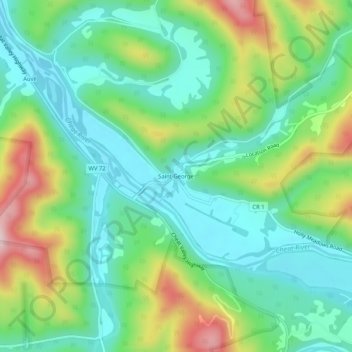
Name: Saint George topographic map, elevation, terrain.
Location: Saint George, Tucker County, West Virginia, United States (39.14681 -79.72224 39.18681 -79.68224)
Average elevation: 1,847 ft
Minimum elevation: 1,503 ft
Maximum elevation: 2,589 ft
Tucker County trails, hiking, mountain biking, running and outdoor activities
Make a donation
Gear up for your next adventure:
As an Amazon Associate, this site earns from qualifying purchases at no extra cost to you.
Other topographic maps
Click on a map to view its topography, its elevation and its terrain.
Dolly Sods Wilderness
United States > West Virginia > Tucker County
Dolly Sods is a rocky, high-altitude plateau with sweeping vistas and lifeforms normally found much farther north in Canada. To the north, the distinctive landscape of "the Sods" is characterized by stunted ("flagged") trees, wind-carved boulders, heath barrens, grassy meadows created in the last century by…
Average elevation: 3,419 ft
Davis
United States > West Virginia > Tucker County
At an elevation of 3,520 feet, Davis has the highest elevation of any West Virginia town.
Average elevation: 3,159 ft
Make a donation
Gear up for your next adventure:
As an Amazon Associate, this site earns from qualifying purchases at no extra cost to you.
Davis
United States > West Virginia > Tucker County
At an elevation of 3,520 feet, Davis has the highest elevation of any West Virginia town. According to the United States Census Bureau, the town has a total area of 1.83 square miles (4.74 km2), all land.
Average elevation: 3,159 ft
Canaan Valley Resort State Park
United States > West Virginia > Tucker County
Average elevation: 3,389 ft
Make a donation
Gear up for your next adventure:
As an Amazon Associate, this site earns from qualifying purchases at no extra cost to you.
Canaan Valley Resort State Park
United States > West Virginia > Tucker County
Average elevation: 3,389 ft