
Make a donation
Gear up for your next adventure:
As an Amazon Associate, this site earns from qualifying purchases at no extra cost to you.
Schorn topographic map
Click on the map to display elevation.
Make a donation
Gear up for your next adventure:
As an Amazon Associate, this site earns from qualifying purchases at no extra cost to you.
Schorn
Das Pfarrdorf Schorn liegt nördlich von Pöttmes auf den flachen tertiären Höhen der Aindlinger Terrassentreppe am Südwestrand des Donaumooses. Naturräumlich gehört es also zur Donau-Iller-Lech-Platte, die wiederum Teil des Alpenvorlandes ist, eine der Naturräumlichen Haupteinheiten Deutschlands. Der Einödhof Abenberg nordöstlich von Schorn liegt bereits im Donaumoos, der Bleitzhof westlich von Schorn mitten im Hügelland.
Make a donation
Gear up for your next adventure:
As an Amazon Associate, this site earns from qualifying purchases at no extra cost to you.
About this map
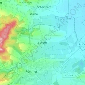
Name: Schorn topographic map, elevation, terrain.
Average elevation: 1,348 ft
Minimum elevation: 1,263 ft
Maximum elevation: 1,673 ft
Make a donation
Gear up for your next adventure:
As an Amazon Associate, this site earns from qualifying purchases at no extra cost to you.
Other topographic maps
Click on a map to view its topography, its elevation and its terrain.