
Thank you for supporting this site ❤️
Make a donation
Make a donation
Gear up for your next adventure:
As an Amazon Associate, this site earns from qualifying purchases at no extra cost to you.
Poggetello topographic map
Click on the map to display elevation.
Thank you for supporting this site ❤️
Make a donation
Make a donation
Gear up for your next adventure:
As an Amazon Associate, this site earns from qualifying purchases at no extra cost to you.
About this map
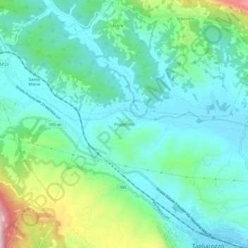
Name: Poggetello topographic map, elevation, terrain.
Location: Poggetello, Tagliacozzo, L'Aquila, Abruzzo, 67069, Italia (42.06897 13.21649 42.10897 13.25649)
Average elevation: 2,723 ft
Minimum elevation: 2,388 ft
Maximum elevation: 3,799 ft
Thank you for supporting this site ❤️
Make a donation
Make a donation
Gear up for your next adventure:
As an Amazon Associate, this site earns from qualifying purchases at no extra cost to you.