
Thank you for supporting this site ❤️
Make a donation
Make a donation
Gear up for your next adventure:
As an Amazon Associate, this site earns from qualifying purchases at no extra cost to you.
Gairsain topographic map
Click on the map to display elevation.
Thank you for supporting this site ❤️
Make a donation
Make a donation
Gear up for your next adventure:
As an Amazon Associate, this site earns from qualifying purchases at no extra cost to you.
About this map
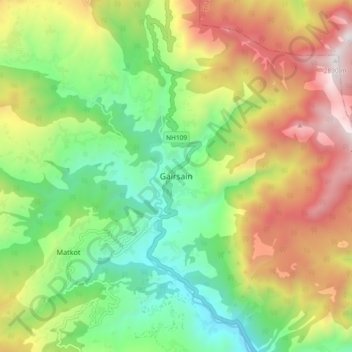
Name: Gairsain topographic map, elevation, terrain.
Location: Gairsain, Chamoli, Uttarakhand, 246428, India (30.01462 79.24999 30.09462 79.32999)
Average elevation: 6,496 ft
Minimum elevation: 4,472 ft
Maximum elevation: 9,426 ft
Thank you for supporting this site ❤️
Make a donation
Make a donation
Gear up for your next adventure:
As an Amazon Associate, this site earns from qualifying purchases at no extra cost to you.