
Thank you for supporting this site ❤️
Make a donation
Make a donation
Gear up for your next adventure:
As an Amazon Associate, this site earns from qualifying purchases at no extra cost to you.
Montenebro topographic map
Click on the map to display elevation.
Thank you for supporting this site ❤️
Make a donation
Make a donation
Gear up for your next adventure:
As an Amazon Associate, this site earns from qualifying purchases at no extra cost to you.
About this map
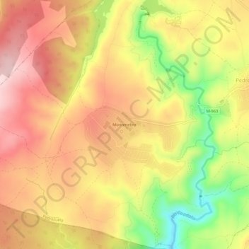
Name: Montenebro topographic map, elevation, terrain.
Location: Montenebro, Pedrezuela, Comunidad de Madrid, 28723, España (40.71796 -3.64955 40.75796 -3.60955)
Average elevation: 2,812 ft
Minimum elevation: 2,274 ft
Maximum elevation: 3,189 ft
Thank you for supporting this site ❤️
Make a donation
Make a donation
Gear up for your next adventure:
As an Amazon Associate, this site earns from qualifying purchases at no extra cost to you.
Other topographic maps
Click on a map to view its topography, its elevation and its terrain.
Embalse de Pedrezuela
España > Comunidad de Madrid > Pedrezuela > Atalaya Real
Average elevation: 2,782 ft