Geolocate

Cambuja topographic map

Click on the map to display elevation.

About this map

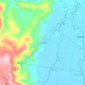
Name: Cambuja topographic map, elevation, terrain.

Location: Cambuja, Santa Maria, Laguna, Calabarzon, 4022, Philippines (14.44733 121.38266 14.48733 121.42266)

Average elevation: 226 ft

Minimum elevation: 13 ft

Maximum elevation: 876 ft

Gear up for your next adventure:

🪶Camping Sleeping Pad - Comfortable sleeping pad for backpacking
🏕️Family Camping Gear - Essentials for group camping trips
🔭Telescopic Hiking Pole - Adjustable pole for hiking stability
📦Dry Bags Set - Waterproof storage for electronics and clothes
🎒Outdoor Daypacks - Lightweight backpacks designed for carrying maps and essential gear

As an Amazon Associate, this site earns from qualifying purchases at no extra cost to you.