Geolocate

Jolo topographic map

Click on the map to display elevation.

About this map

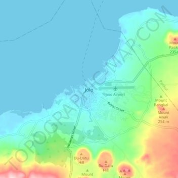
Name: Jolo topographic map, elevation, terrain.

Location: Jolo, Sulu, Zamboanga Peninsula, 7400, Philippines (6.01312 120.96076 6.09312 121.04076)

Average elevation: 187 ft

Minimum elevation: -3 ft

Maximum elevation: 961 ft

Other topographic maps

Click on a map to view its topography, its elevation and its terrain.

Lugus Island

Philippines > Sulu

Average elevation: 66 ft

Bambannan Island

Philippines > Sulu

Average elevation: 0 ft

Dammi Island

Philippines > Sulu

Average elevation: 0 ft

Lugus

Philippines > Sulu

Average elevation: 23 ft

Siasi

Philippines > Sulu

Average elevation: 23 ft

Seit Lake

Philippines > Sulu > Old Panamao

Average elevation: 46 ft

North Ubian Island

Philippines > Sulu > Pangutaran

Average elevation: 7 ft

Simisa Island

Philippines > Sulu > Banguingui

Average elevation: 7 ft

Kulassian Island

Philippines > Sulu > Pangutaran

Average elevation: 0 ft

Jolo Island

Philippines > Sulu

Average elevation: 92 ft

Patikul

Philippines > Sulu

Average elevation: 164 ft

Pangutaran

Philippines > Sulu

Average elevation: 13 ft

Siasi Island

Philippines > Sulu > Siasi

Average elevation: 154 ft

Siasi

Philippines > Sulu

Average elevation: 23 ft

Gear up for your next adventure:

🔊Portable Camp Speaker - Music and alerts at camp
🌎3D Topographic Globes - Raised relief globes for a tactile understanding of geography
🏫Relief Map Kits - Hands-on tools for teaching landforms and elevation
🥤Water Filter Bottle - All‑in‑one filter bottle for safe hydration
🎒Trail Energy Bars - High‑calorie bars for hiking energy

As an Amazon Associate, this site earns from qualifying purchases at no extra cost to you.