
Make a donation
Gear up for your next adventure:
As an Amazon Associate, this site earns from qualifying purchases at no extra cost to you.
Touws River topographic map
Click on the map to display elevation.
Make a donation
Gear up for your next adventure:
As an Amazon Associate, this site earns from qualifying purchases at no extra cost to you.
Touws River
Touws River is located at an elevation of 770 metres (2,530 ft) on the southwestern edge of the Great Karoo, east of the Hex River Mountains and north of the Langeberg, at the point where the Donkeys River flows into the Touws River. It lies just to the south of the N1 highway, 180 kilometres (110 mi) by road from Cape Town. The railway line passes through the town, with the yards and depot being located just to the north-east; by rail it is 257 kilometres (160 mi) from Cape Town.
Make a donation
Gear up for your next adventure:
As an Amazon Associate, this site earns from qualifying purchases at no extra cost to you.
About this map
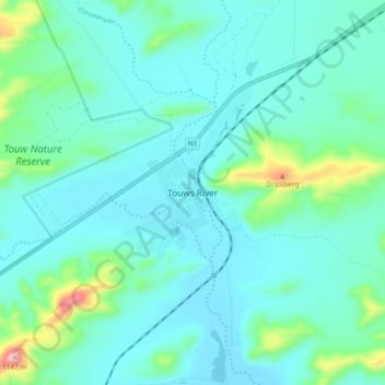
Name: Touws River topographic map, elevation, terrain.
Average elevation: 2,697 ft
Minimum elevation: 2,493 ft
Maximum elevation: 3,753 ft
Make a donation
Gear up for your next adventure:
As an Amazon Associate, this site earns from qualifying purchases at no extra cost to you.
Other topographic maps
Click on a map to view its topography, its elevation and its terrain.
Hex River
South Africa > Western Cape > Cape Winelands District Municipality > Breede Valley Local Municipality
Average elevation: 2,113 ft
Breede River
South Africa > Western Cape > Cape Winelands District Municipality > Breede Valley Local Municipality
Average elevation: 719 ft