
Thank you for supporting this site ❤️
Make a donation
Make a donation
Gear up for your next adventure:
As an Amazon Associate, this site earns from qualifying purchases at no extra cost to you.
Thanewal topographic map
Click on the map to display elevation.
Thank you for supporting this site ❤️
Make a donation
Make a donation
Gear up for your next adventure:
As an Amazon Associate, this site earns from qualifying purchases at no extra cost to you.
About this map
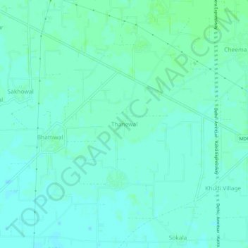
Name: Thanewal topographic map, elevation, terrain.
Location: Thanewal, Batala Tahsil, Gurdaspur, Punjab, 143515, India (31.68865 75.39391 31.72865 75.43391)
Average elevation: 830 ft
Minimum elevation: 817 ft
Maximum elevation: 843 ft
Thank you for supporting this site ❤️
Make a donation
Make a donation
Gear up for your next adventure:
As an Amazon Associate, this site earns from qualifying purchases at no extra cost to you.