Geolocate

Palmas topographic map

Click on the map to display elevation.

Palmas

Palmas is a municipality in the south of the Brazilian state of Paraná. Palmas is located in the mountainous area of Paraná and is in the mesoregion of South-Central Paraná. Palmas is the capital of the microregion of the same name. The population is 51,755 (2020 est.) in an area of 1557.90 km2. The elevation is 1,056 m.

Wikipedia (CC-BY-SA 3.0)

About this map

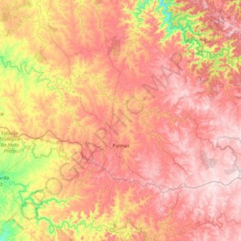
Name: Palmas topographic map, elevation, terrain.

Location: Palmas, Região Geográfica Imediata de Pato Branco, Região Geográfica Intermediária de Cascavel, Paraná, South Region, 85555-000, Brazil (-26.59934 -52.17824 -26.24345 -51.51190)

Average elevation: 3,428 ft

Minimum elevation: 2,283 ft

Maximum elevation: 4,331 ft

Gear up for your next adventure:

🪶Trail Camera - Capture wildlife on your hikes
🔊Portable Camp Speaker - Music and alerts at camp
☀️Outdoor Sunscreen - High protection sunscreen for outdoor activities
🧴Hand Sanitizer - Keep hands clean while hiking
🛌Ultralight Sleeping Bags - Compact down bags for cold nights in the wilderness

As an Amazon Associate, this site earns from qualifying purchases at no extra cost to you.