
Make a donation
Gear up for your next adventure:
As an Amazon Associate, this site earns from qualifying purchases at no extra cost to you.
Proven topographic map
Click on the map to display elevation.
Make a donation
Gear up for your next adventure:
As an Amazon Associate, this site earns from qualifying purchases at no extra cost to you.
Proven
Proven ligt in Zandlemig Vlaanderen op een hoogte van 9 tot 31 meter. De kom ligt op ongeveer 20 meter hoogte. De Bossen tussen Sint-Jan-ter-Biezen en Sint-Sixtusabdij vormen een landschappelijk en cultuurhistorisch belangrijk gebied. Waterlopen zijn de Klijtebeek en de Haringebeek.
Make a donation
Gear up for your next adventure:
As an Amazon Associate, this site earns from qualifying purchases at no extra cost to you.
About this map
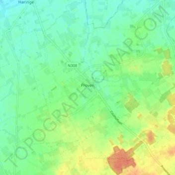
Name: Proven topographic map, elevation, terrain.
Location: Proven, Poperinge, Ieper, West-Vlaanderen, 8972, België (50.86455 2.62125 50.91478 2.69946)
Average elevation: 52 ft
Minimum elevation: 3 ft
Maximum elevation: 138 ft
Make a donation
Gear up for your next adventure:
As an Amazon Associate, this site earns from qualifying purchases at no extra cost to you.
Other topographic maps
Click on a map to view its topography, its elevation and its terrain.
Roesbrugge
België > West-Vlaanderen > Ieper > Poperinge
Roesbrugge ligt aan de IJzer op een hoogte van ongeveer 7 meter. Naar het zuidoosten toe strekt Zandlemig Vlaanderen zich uit, met lichte glooiing. De IJzervallei tussen Roesbrugge-Haringe en Elzendamme en de vallei van de Poperingevaart is een cultuurhistorische ankerplaats.
Average elevation: 23 ft