
Make a donation
Gear up for your next adventure:
As an Amazon Associate, this site earns from qualifying purchases at no extra cost to you.
Ranya topographic map
Click on the map to display elevation.
Make a donation
Gear up for your next adventure:
As an Amazon Associate, this site earns from qualifying purchases at no extra cost to you.
Ranya
Ranya is located in the Sulaymaniyah Governorate in the Kurdistan Region of Iraq, approximately 70 km northeast of Sulaymaniyah city. It is situated near the Hawraman Mountains and lies at an altitude of about 1,300 meters.
Make a donation
Gear up for your next adventure:
As an Amazon Associate, this site earns from qualifying purchases at no extra cost to you.
About this map
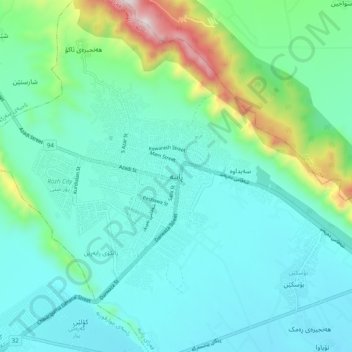
Name: Ranya topographic map, elevation, terrain.
Average elevation: 2,224 ft
Minimum elevation: 1,650 ft
Maximum elevation: 4,613 ft
Make a donation
Gear up for your next adventure:
As an Amazon Associate, this site earns from qualifying purchases at no extra cost to you.
Other topographic maps
Click on a map to view its topography, its elevation and its terrain.
Darbandikhan Dam
Iraq > Sulaymaniyah Governorate > Darbandikhan
The dam is located within a gorge on a foundation of sedimentary rocks. It is a rock-fill embankment type with a central clay core. The dam is 128 m (420 ft) tall and 445 m (1,460 ft) long (535 m (1,755 ft) if the spillway section is included). Its crest is 17 m (56 ft) wide and at an elevation of 495 m (1,624…
Average elevation: 1,873 ft
Make a donation
Gear up for your next adventure:
As an Amazon Associate, this site earns from qualifying purchases at no extra cost to you.
Make a donation
Gear up for your next adventure:
As an Amazon Associate, this site earns from qualifying purchases at no extra cost to you.
Make a donation
Gear up for your next adventure:
As an Amazon Associate, this site earns from qualifying purchases at no extra cost to you.
Make a donation
Gear up for your next adventure:
As an Amazon Associate, this site earns from qualifying purchases at no extra cost to you.
Make a donation
Gear up for your next adventure:
As an Amazon Associate, this site earns from qualifying purchases at no extra cost to you.
Make a donation
Gear up for your next adventure:
As an Amazon Associate, this site earns from qualifying purchases at no extra cost to you.
Make a donation
Gear up for your next adventure:
As an Amazon Associate, this site earns from qualifying purchases at no extra cost to you.