
Make a donation
Gear up for your next adventure:
As an Amazon Associate, this site earns from qualifying purchases at no extra cost to you.
Merendree topographic map
Click on the map to display elevation.
Make a donation
Gear up for your next adventure:
As an Amazon Associate, this site earns from qualifying purchases at no extra cost to you.
Merendree
Merendree ligt op een hoogte van ongeveer 10 meter met in het westen het Schipdonkkanaal en in het oosten de Oude Kale. Ten noorden van Merendree vindt men bovendien het Kanaal Gent-Brugge, dat het Schipdonkkanaal kruist.
Make a donation
Gear up for your next adventure:
As an Amazon Associate, this site earns from qualifying purchases at no extra cost to you.
About this map
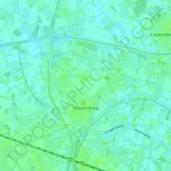
Name: Merendree topographic map, elevation, terrain.
Location: Merendree, Deinze, Gent, Oost-Vlaanderen, Vlaanderen, België (51.06547 3.54765 51.10113 3.61315)
Average elevation: 20 ft
Minimum elevation: 10 ft
Maximum elevation: 36 ft
Make a donation
Gear up for your next adventure:
As an Amazon Associate, this site earns from qualifying purchases at no extra cost to you.
Other topographic maps
Click on a map to view its topography, its elevation and its terrain.
Vinkt
België > Oost-Vlaanderen > Gent > Deinze
Vinkt ligt in Zandig Vlaanderen op een lichte hoogte van iets meer dan 20 m. In het noorden loopt de Poekebeek en meer zuidelijk de Reigersbeek. Beide beken lopen naar het oosten, in de richting van de Oude Kale.
Average elevation: 39 ft