
Thank you for supporting this site ❤️
Make a donation
Make a donation
Gear up for your next adventure:
As an Amazon Associate, this site earns from qualifying purchases at no extra cost to you.
Trois-Rods topographic map
Click on the map to display elevation.
Thank you for supporting this site ❤️
Make a donation
Make a donation
Gear up for your next adventure:
As an Amazon Associate, this site earns from qualifying purchases at no extra cost to you.
About this map
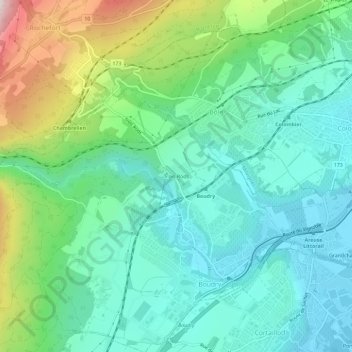
Name: Trois-Rods topographic map, elevation, terrain.
Location: Trois-Rods, Boudry, Neuchâtel, 2017, Suisse (46.94100 6.81030 46.98100 6.85030)
Average elevation: 1,857 ft
Minimum elevation: 1,414 ft
Maximum elevation: 3,071 ft
Thank you for supporting this site ❤️
Make a donation
Make a donation
Gear up for your next adventure:
As an Amazon Associate, this site earns from qualifying purchases at no extra cost to you.