
Buriton topographic map
Click on the map to display elevation.
About this map
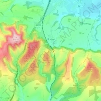
Name: Buriton topographic map, elevation, terrain.
Location: Buriton, East Hampshire, Hampshire, England, United Kingdom (50.94272 -0.98635 50.99870 -0.90564)
Average elevation: 410 ft
Minimum elevation: 151 ft
Maximum elevation: 883 ft
Other topographic maps
Click on a map to view its topography, its elevation and its terrain.
Ditcham Woods.
United Kingdom > England > Hampshire > East Hampshire > Buriton
Average elevation: 446 ft