Geolocate

Magenta topographic map

Click on the map to display elevation.

About this map

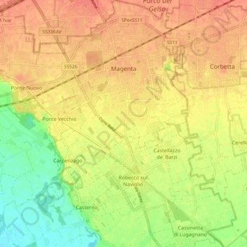
Name: Magenta topographic map, elevation, terrain.

Location: Magenta, Milan, Lombardy, 20013, Italy (45.41942 8.81706 45.48298 8.90734)

Average elevation: 433 ft

Minimum elevation: 341 ft

Maximum elevation: 489 ft

Other topographic maps

Click on a map to view its topography, its elevation and its terrain.

Milan

Italy > Lombardy > Milan > Milan

Average elevation: 427 ft

Tregarezzo

Italy > Lombardy > Milan > Segrate > San Felice

Average elevation: 377 ft

Cascina Confaloniera

Italy > Lombardy > Milan > Rosate

Average elevation: 351 ft

Vaiano Valle

Italy > Lombardy > Milan > Milan

Average elevation: 361 ft

Gear up for your next adventure:

👖Convertible Hiking Pants - Versatile zip-off pants for changing altitudes and temperatures
☀️Outdoor Sunscreen - High protection sunscreen for outdoor activities
🪶Camping Sleeping Pad - Comfortable sleeping pad for backpacking
🎒Waterproof Dry Bags - Keep your electronics and maps dry inside your pack
Backpacking Tents - Weight-optimized shelters for multi-day topographic surveys

As an Amazon Associate, this site earns from qualifying purchases at no extra cost to you.