Geolocate

Good Night topographic map

Click on the map to display elevation.

About this map

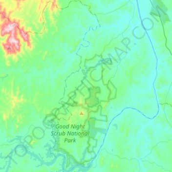
Name: Good Night topographic map, elevation, terrain.

Location: Good Night, Bundaberg Region, Queensland, Australia (-25.36133 151.81258 -25.14146 152.01374)

Average elevation: 358 ft

Minimum elevation: 66 ft

Maximum elevation: 1,923 ft

Other topographic maps

Click on a map to view its topography, its elevation and its terrain.

Gin Gin

Australia > Queensland > Bundaberg Region > Gin Gin

Average elevation: 240 ft

Isis River

Australia > Queensland > Bundaberg Region > Buxton

Average elevation: 39 ft

Burrum River

Australia > Queensland > Bundaberg Region > Buxton

Average elevation: 66 ft

Woodgate Beach

Australia > Queensland > Bundaberg Region

Average elevation: 10 ft

Bundaberg

Australia > Queensland > Bundaberg Region

Average elevation: 59 ft

Bundaberg

Australia > Queensland > Bundaberg Region

Average elevation: 59 ft

Gear up for your next adventure:

🪵Folding Camp Saw - Compact saw for wood and campsite work
🛠️Outdoor Gear Repair Kit - Essential tools to fix gear on the trail
🧯Emergency Survival Kit - All‑in‑one survival essentials for the backcountry
🥘Titanium Cookware - Durable, featherlight pots and pans for backpacking
🛰️Handheld GPS Units - Professional satellite navigators for precise backcountry mapping

As an Amazon Associate, this site earns from qualifying purchases at no extra cost to you.