Geolocate
👉 Easily get elevation data in JSON, GeoTIFF and KML formats using Elevation API
Thank you for supporting this site ❤️
Make a donation

Minerva topographic map

Click on the map to display elevation.

👉 Easily get elevation data in JSON, GeoTIFF and KML formats using Elevation API
Thank you for supporting this site ❤️
Make a donation

About this map

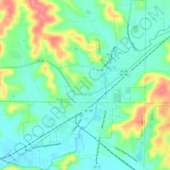
Name: Minerva topographic map, elevation, terrain.

Location: Minerva, Stark County, Ohio, United States (40.71256 -81.12389 40.75126 -81.08155)

Average elevation: 1,109 ft

Minimum elevation: 1,020 ft

Maximum elevation: 1,289 ft

Stark County trails, hiking, mountain biking, running and outdoor activities

Other topographic maps

Click on a map to view its topography, its elevation and its terrain.

Mount Pleasant

United States > Ohio > Stark County

Average elevation: 1,155 ft

Deer Creek

United States > Ohio > Stark County > Lexington

Average elevation: 1,047 ft

Sippo Heights

United States > Ohio > Stark County > Massillon

Average elevation: 1,043 ft

Cairo

United States > Ohio > Stark County

Average elevation: 1,145 ft

Lake Cable

United States > Ohio > Stark County

Average elevation: 1,115 ft

North Industry

United States > Ohio > Stark County

Average elevation: 1,093 ft

New Franklin

United States > Ohio > Stark County

Average elevation: 1,198 ft

Gear up for your next adventure:

🌡️Handheld Weather Meters - Measure wind, temp, and pressure for safe mountain travel
🔦Powerful Headlamps - Ultra-bright hands-free lighting for night navigation
🎁Geography Themed Gifts - Unique gift ideas for map lovers and geography enthusiasts
🧦Merino Wool Socks - Moisture-wicking, blister-preventing socks for long treks
🌎3D Topographic Globes - Raised relief globes for a tactile understanding of geography

As an Amazon Associate, this site earns from qualifying purchases at no extra cost to you.