Geolocate

Baronissi topographic map

Click on the map to display elevation.

About this map

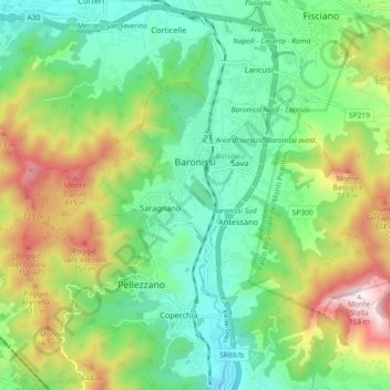
Name: Baronissi topographic map, elevation, terrain.

Location: Baronissi, Salerno, Campania, 84081, Italy (40.72091 14.73028 40.76114 14.82136)

Average elevation: 1,188 ft

Minimum elevation: 226 ft

Maximum elevation: 3,091 ft

Other topographic maps

Click on a map to view its topography, its elevation and its terrain.

Monte Cervati

Italy > Campania > Salerno > Sanza

Average elevation: 5,322 ft

Catona

Italy > Campania > Salerno

Average elevation: 1,404 ft

Civitella

Italy > Campania > Salerno > Moio della Civitella

Average elevation: 2,014 ft

Iaconti

Italy > Campania > Salerno > Vietri sul Mare

Average elevation: 935 ft

Erchie

Italy > Campania > Salerno > Maiori

Average elevation: 430 ft

Ariano

Italy > Campania > Salerno

Average elevation: 922 ft

Bosco

Italy > Campania > Salerno

Average elevation: 1,273 ft

San Severino

Italy > Campania > Salerno > Centola

Average elevation: 896 ft

Pogerola

Italy > Campania > Salerno

Average elevation: 1,191 ft

Montepertuso

Italy > Campania > Salerno > Arienzo

Average elevation: 1,493 ft

Gear up for your next adventure:

🛡️Bear Spray Outdoor - Protection in bear country hikes
🥾Men's Hiking Boots - Durable, waterproof footwear for rugged terrain and steep inclines
🍳Camping Cook Set - Complete cookware for outdoor meals
🧴Hand Sanitizer - Keep hands clean while hiking
🔦Compact Flashlight - Reliable flashlight for emergencies

As an Amazon Associate, this site earns from qualifying purchases at no extra cost to you.