Geolocate

Huachipa topographic map

Click on the map to display elevation.

About this map

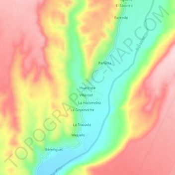
Name: Huachipa topographic map, elevation, terrain.

Location: Huachipa, Vítor, Arequipa, Perú (-16.56283 -71.99263 -16.52283 -71.95263)

Average elevation: 3,842 ft

Minimum elevation: 3,389 ft

Maximum elevation: 4,249 ft

Gear up for your next adventure:

👟Trail Running Shoes - Lightweight shoes for trail runners
🔥Camping Stove - Portable stove for camping and backcountry cooking
🌄Hiking Binoculars - Compact binoculars for scenic views and trail spotting
🧣Hiking Neck Gaiter - Multi‑use neck protection for outdoor weather
🗺️NatGeo Topo Maps - High-quality waterproof printed topographic maps of US Parks

As an Amazon Associate, this site earns from qualifying purchases at no extra cost to you.