
Make a donation
Gear up for your next adventure:
As an Amazon Associate, this site earns from qualifying purchases at no extra cost to you.
Grassy topographic map
Click on the map to display elevation.
Make a donation
Gear up for your next adventure:
As an Amazon Associate, this site earns from qualifying purchases at no extra cost to you.
About this map
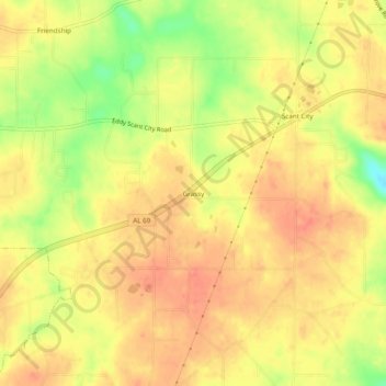
Name: Grassy topographic map, elevation, terrain.
Location: Grassy, Marshall County, Alabama, United States (34.33426 -86.45665 34.37426 -86.41665)
Average elevation: 1,014 ft
Minimum elevation: 892 ft
Maximum elevation: 1,070 ft
Make a donation
Gear up for your next adventure:
As an Amazon Associate, this site earns from qualifying purchases at no extra cost to you.
Other topographic maps
Click on a map to view its topography, its elevation and its terrain.
Arab
United States > Alabama > Marshall County
Arab is located at an elevation of 1,100 feet (340 m) on top of Brindlee Mountain, near the southwest end of the Appalachian Plateau. The city is primarily in southern Marshall County; a small portion extends south into Cullman County. U.S. Route 231 runs north-to-south through Arab, and State Route 69 runs…
Average elevation: 1,030 ft
Albertville
United States > Alabama > Marshall County
According to the U.S. Census Bureau, Albertville has a total area of 27.0 square miles (69.9 km2), of which 0.1 square miles (0.3 km2), or 0.37%, are water. The city sits at an elevation of 1,060 feet (320 m) atop Sand Mountain, a plateau that in this area is about 15 miles (24 km) wide. The Tennessee Valley…
Average elevation: 1,014 ft
Albertville
United States > Alabama > Marshall County
The city sits at an elevation of 1,060 feet (320 m) atop Sand Mountain, a plateau that in this area is about 15 miles (24 km) wide. The Tennessee Valley Divide passes through the southern part of the city. The majority of the city drains north to Short Creek, a tributary of the Tennessee River, while the…
Average elevation: 1,014 ft
Make a donation
Gear up for your next adventure:
As an Amazon Associate, this site earns from qualifying purchases at no extra cost to you.
Arab
United States > Alabama > Marshall County
Arab is located at an elevation of 1,100 feet (340 m) on top of Brindlee Mountain, near the southwest end of the Appalachian Plateau. The city is primarily in southern Marshall County; a small portion extends south into Cullman County. U.S. Route 231 runs north-to-south through Arab, and State Route 69 runs…
Average elevation: 1,030 ft
Albertville
United States > Alabama > Marshall County
The city sits at an elevation of 1,060 feet (320 m) atop Sand Mountain, a plateau that in this area is about 15 miles (24 km) wide. The Tennessee Valley Divide passes through the southern part of the city. The majority of the city drains north to Short Creek, a tributary of the Tennessee River, while the…
Average elevation: 1,014 ft