Geolocate

Rio topographic map

Click on the map to display elevation.

About this map

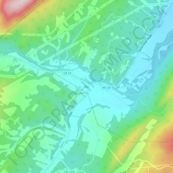
Name: Rio topographic map, elevation, terrain.

Location: Rio, Hampshire County, West Virginia, 26714, United States (39.11844 -78.69001 39.15844 -78.65001)

Average elevation: 1,355 ft

Minimum elevation: 1,027 ft

Maximum elevation: 2,323 ft

Hampshire County trails, hiking, mountain biking, running and outdoor activities

Other topographic maps

Click on a map to view its topography, its elevation and its terrain.

Romney

United States > West Virginia > Hampshire County

Average elevation: 817 ft

Romney

United States > West Virginia > Hampshire County

Average elevation: 817 ft

Romney

United States > West Virginia > Hampshire County

Average elevation: 817 ft

Gear up for your next adventure:

🧦Hiking Socks - Comfortable socks to prevent blisters on long hikes
🪶Multi‑Purpose Knife - Useful blade for camp and trail
🥘Titanium Cookware - Durable, featherlight pots and pans for backpacking
🪶Camping Sleeping Pad - Comfortable sleeping pad for backpacking
🧭Map Reading Tools - Tools and kits for map navigation

As an Amazon Associate, this site earns from qualifying purchases at no extra cost to you.