
Make a donation
Gear up for your next adventure:
As an Amazon Associate, this site earns from qualifying purchases at no extra cost to you.
Himmighausen topographic map
Click on the map to display elevation.
Make a donation
Gear up for your next adventure:
As an Amazon Associate, this site earns from qualifying purchases at no extra cost to you.
Himmighausen
Himmighausen liegt an der Mündung des Fischbachs in die Emmer. In dem Ort, der im Bergtal am Fuße des Eggegebirges liegt, wohnen rund 460 Einwohner. Auf der Gemarkung Himmighausen-Bahnhof befindet sich der Lindenberg, der eine Höhe von 288 m ü. NHN erreicht. Auf dem Berg steht die alte Antonius-Linde.
Make a donation
Gear up for your next adventure:
As an Amazon Associate, this site earns from qualifying purchases at no extra cost to you.
About this map
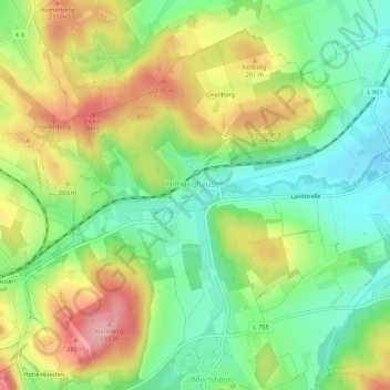
Name: Himmighausen topographic map, elevation, terrain.
Average elevation: 735 ft
Minimum elevation: 538 ft
Maximum elevation: 997 ft
Make a donation
Gear up for your next adventure:
As an Amazon Associate, this site earns from qualifying purchases at no extra cost to you.
Other topographic maps
Click on a map to view its topography, its elevation and its terrain.
Holzhausen
Deutschland > Nordrhein-Westfalen > Kreis Höxter > Nieheim > Holzhausen
Average elevation: 791 ft