
Make a donation
Gear up for your next adventure:
As an Amazon Associate, this site earns from qualifying purchases at no extra cost to you.
Cata topographic map
Click on the map to display elevation.
Make a donation
Gear up for your next adventure:
As an Amazon Associate, this site earns from qualifying purchases at no extra cost to you.
About this map
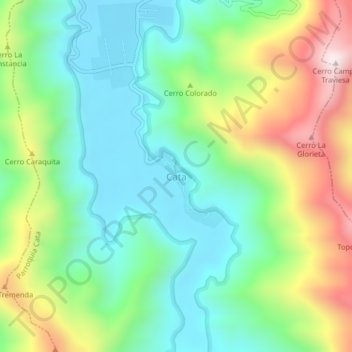
Name: Cata topographic map, elevation, terrain.
Average elevation: 801 ft
Minimum elevation: 13 ft
Maximum elevation: 2,362 ft
Make a donation
Gear up for your next adventure:
As an Amazon Associate, this site earns from qualifying purchases at no extra cost to you.
Other topographic maps
Click on a map to view its topography, its elevation and its terrain.
Parque Nacional Henri Pittier
Venezuela > Estado Aragua > Municipio Ocumare
Presenta una alta diversidad debido a la gran cantidad de ambientes involucrados. Los chaparros (Curatella americana, Bowdichia virgilioides), las majaguas (Heliocarpus sp.) y el palo maría (Triplaris sp.) son característicos de los bosques a menor altitud. El cucharón o niño (Gyranthera caribensis) es…
Average elevation: 1,667 ft