Geolocate

Maggiora topographic map

Click on the map to display elevation.

About this map

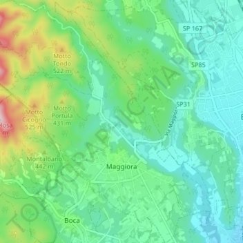
Name: Maggiora topographic map, elevation, terrain.

Location: Maggiora, Novara, Piemonte, 28014, Italia (45.67462 8.38071 45.72122 8.44678)

Average elevation: 1,253 ft

Minimum elevation: 971 ft

Maximum elevation: 2,077 ft

Other topographic maps

Click on a map to view its topography, its elevation and its terrain.

Sovazza

Italia > Piemonte > Novara

Average elevation: 2,238 ft

Gaggiolo

Italia > Piemonte > Novara

Average elevation: 692 ft

Gattico

Italia > Piemonte > Novara

Average elevation: 1,109 ft

Fosseno

Italia > Piemonte > Novara

Average elevation: 1,798 ft

Coiromonte

Italia > Piemonte > Novara

Average elevation: 2,425 ft

Tabarino

Italia > Piemonte > Novara

Average elevation: 1,821 ft

Gear up for your next adventure:

🪑Ultralight Camp Chairs - Portable seating for resting after a long day of mapping
🛡️Insect Repellent - Protection against bugs during outdoor activities
🔥Camping Stove - Portable stove for camping and backcountry cooking
📦Dry Bags Set - Waterproof storage for electronics and clothes
🦶Carbon Trekking Poles - Reduce knee impact on steep descents with ultra-light poles

As an Amazon Associate, this site earns from qualifying purchases at no extra cost to you.