
Make a donation
Gear up for your next adventure:
As an Amazon Associate, this site earns from qualifying purchases at no extra cost to you.
Tota topographic map
Click on the map to display elevation.
Make a donation
Gear up for your next adventure:
As an Amazon Associate, this site earns from qualifying purchases at no extra cost to you.
About this map
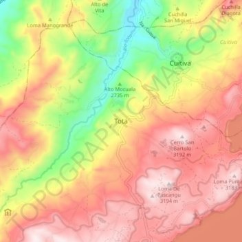
Name: Tota topographic map, elevation, terrain.
Average elevation: 9,557 ft
Minimum elevation: 8,297 ft
Maximum elevation: 10,525 ft
Make a donation
Gear up for your next adventure:
As an Amazon Associate, this site earns from qualifying purchases at no extra cost to you.
Other topographic maps
Click on a map to view its topography, its elevation and its terrain.
Laguna de Tota
Colombia > Boyacá > Tota > Aquitania
Con una superficie cercana a los 55 km² es el lago más grande de Colombia. Además, después del Titicaca es el segundo lago navegable a mayor altitud de América del Sur, al estar ubicado a 3015 m s. n. m..
Average elevation: 10,135 ft
Ronda de Protección del Lago de Tota
Colombia > Boyacá > Tota > Aquitania
Average elevation: 10,141 ft
Ronda de Protección del Lago de Tota
Colombia > Boyacá > Tota > Aquitania
Average elevation: 10,141 ft