
Make a donation
Gear up for your next adventure:
As an Amazon Associate, this site earns from qualifying purchases at no extra cost to you.
Wadern topographic map
Click on the map to display elevation.
Make a donation
Gear up for your next adventure:
As an Amazon Associate, this site earns from qualifying purchases at no extra cost to you.
Wadern
Zwar deuten einige Einzelfunde, wie etwa einzelne Steinbeile sowie ein bronzezeitlicher Grabhügel in Nunkirchen, bereits auf eine vorgeschichtliche Besiedelung der Region hin, doch mehren sich erst für den Zeitraum ab etwa 1.000 v. Chr. aussagekräftige Funde und Befunde. Dabei finden sich auf den Höhen des Hochwalds vor allem ab der frühkeltischen Eisenzeit zahlreiche aufwändige Bestattungen unter Grabhügeln, die auf das Vorhandensein einer reichen keltischen Oberschicht mit Handelskontakten bis in den Mittelmeerraum hinweisen. Im Stadtgebiet Wadern sind hier die im 5./4. vorchristlichen Jahrhundert entlang einer antiken Wegeführung angelegten neun Grabhügel mit mehreren reich ausgestatteten Beisetzungen bei Gehweiler zu nennen.
Make a donation
Gear up for your next adventure:
As an Amazon Associate, this site earns from qualifying purchases at no extra cost to you.
About this map
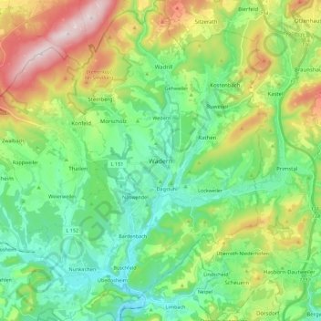
Name: Wadern topographic map, elevation, terrain.
Location: Wadern, Landkreis Merzig-Wadern, Saarland, 66687, Deutschland (49.46893 6.79988 49.61303 6.96296)
Average elevation: 1,253 ft
Minimum elevation: 764 ft
Maximum elevation: 2,300 ft
Make a donation
Gear up for your next adventure:
As an Amazon Associate, this site earns from qualifying purchases at no extra cost to you.
Other topographic maps
Click on a map to view its topography, its elevation and its terrain.
Stausee Losheim
Deutschland > Saarland > Landkreis Merzig-Wadern > Losheim am See
Average elevation: 1,086 ft
Make a donation
Gear up for your next adventure:
As an Amazon Associate, this site earns from qualifying purchases at no extra cost to you.
Naturschutzgebiet Wadrilltal
Deutschland > Saarland > Landkreis Merzig-Wadern > Wadern
Average elevation: 1,060 ft
Make a donation
Gear up for your next adventure:
As an Amazon Associate, this site earns from qualifying purchases at no extra cost to you.
Fallenseifenberg
Deutschland > Saarland > Landkreis Merzig-Wadern > Wadern
Average elevation: 1,539 ft
Reidelbach
Deutschland > Saarland > Landkreis Merzig-Wadern > Wadern > Wedern
Average elevation: 1,296 ft
Make a donation
Gear up for your next adventure:
As an Amazon Associate, this site earns from qualifying purchases at no extra cost to you.
Schimmelkopf
Deutschland > Saarland > Landkreis Merzig-Wadern > Weiskirchen
Average elevation: 1,985 ft
Scheiden
Deutschland > Saarland > Landkreis Merzig-Wadern > Losheim am See > Scheiden
Average elevation: 1,552 ft
Rissenthal
Deutschland > Saarland > Landkreis Merzig-Wadern > Losheim am See > Rissenthal
Average elevation: 1,001 ft
Make a donation
Gear up for your next adventure:
As an Amazon Associate, this site earns from qualifying purchases at no extra cost to you.
Pillinger Hof
Deutschland > Saarland > Landkreis Merzig-Wadern > Perl > Borg
Average elevation: 1,040 ft