
Chartres topographic map
Click on the map to display elevation.
About this map
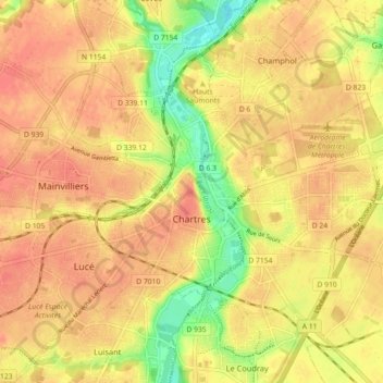
Name: Chartres topographic map, elevation, terrain.
Average elevation: 492 ft
Minimum elevation: 387 ft
Maximum elevation: 541 ft
Other topographic maps
Click on a map to view its topography, its elevation and its terrain.
Chartres Cathedral
France > Centre-Val de Loire > Eure-et-Loir > Chartres
The elevation of the nave, showing the gallery on the ground level; the narrow triforium; and, on top, the windows of the clerestory
Average elevation: 486 ft
Villarceaux
France > Centre-Val de Loire > Eure-et-Loir > Les Villages Vovéens
Average elevation: 495 ft
Domaine des Evis
France > Centre-Val de Loire > Eure-et-Loir > La Chapelle-Fortin
Average elevation: 722 ft