
Thank you for supporting this site ❤️
Make a donation
Make a donation
Gear up for your next adventure:
As an Amazon Associate, this site earns from qualifying purchases at no extra cost to you.
Chila topographic map
Click on the map to display elevation.
Thank you for supporting this site ❤️
Make a donation
Make a donation
Gear up for your next adventure:
As an Amazon Associate, this site earns from qualifying purchases at no extra cost to you.
About this map
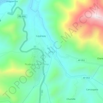
Name: Chila topographic map, elevation, terrain.
Location: Chila, Challhuahuacho, Cotabambas, Apurímac, Perú (-14.15092 -72.24127 -14.11092 -72.20127)
Average elevation: 12,854 ft
Minimum elevation: 12,087 ft
Maximum elevation: 14,764 ft
Thank you for supporting this site ❤️
Make a donation
Make a donation
Gear up for your next adventure:
As an Amazon Associate, this site earns from qualifying purchases at no extra cost to you.