
Thank you for supporting this site ❤️
Make a donation
Make a donation
Gear up for your next adventure:
As an Amazon Associate, this site earns from qualifying purchases at no extra cost to you.
Roc'h Trevezel topographic map
Click on the map to display elevation.
Thank you for supporting this site ❤️
Make a donation
Make a donation
Gear up for your next adventure:
As an Amazon Associate, this site earns from qualifying purchases at no extra cost to you.
Roc'h Trevezel
Le Roc'h Trevezel est le second point culminant de la partie bretonne du Massif armoricain dans les monts d'Arrée. Tout comme le Ménez Kador, il atteint 385 mètres d'altitude.
Thank you for supporting this site ❤️
Make a donation
Make a donation
Gear up for your next adventure:
As an Amazon Associate, this site earns from qualifying purchases at no extra cost to you.
About this map
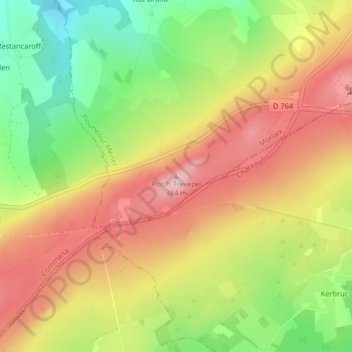
Name: Roc'h Trevezel topographic map, elevation, terrain.
Average elevation: 938 ft
Minimum elevation: 600 ft
Maximum elevation: 1,237 ft
Thank you for supporting this site ❤️
Make a donation
Make a donation
Gear up for your next adventure:
As an Amazon Associate, this site earns from qualifying purchases at no extra cost to you.