
Make a donation
Gear up for your next adventure:
As an Amazon Associate, this site earns from qualifying purchases at no extra cost to you.
Autenried topographic map
Click on the map to display elevation.
Make a donation
Gear up for your next adventure:
As an Amazon Associate, this site earns from qualifying purchases at no extra cost to you.
About this map
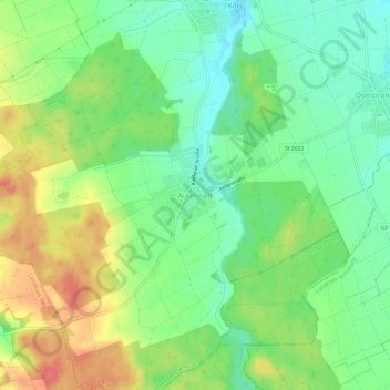
Name: Autenried topographic map, elevation, terrain.
Average elevation: 1,654 ft
Minimum elevation: 1,565 ft
Maximum elevation: 1,775 ft
Make a donation
Gear up for your next adventure:
As an Amazon Associate, this site earns from qualifying purchases at no extra cost to you.
Other topographic maps
Click on a map to view its topography, its elevation and its terrain.
Günz
Deutschland > Bayern > Landkreis Günzburg > Ichenhausen > Hochwang
Zum Schutz vor immer wieder vorkommenden Hochwasserlagen wurde ein überregionaler Schutz mit fünf Hochwasserrückhaltebecken projektiert. Sie bestehen im Wesentlichen aus geschütteten Erddämmen mit einer Höhe von sechs bis zehn Meter, welche das Tal bei Hochwasser gewissermaßen abriegeln. Das in den Damm…
Average elevation: 1,572 ft