
Make a donation
Gear up for your next adventure:
As an Amazon Associate, this site earns from qualifying purchases at no extra cost to you.
Derching topographic map
Click on the map to display elevation.
Make a donation
Gear up for your next adventure:
As an Amazon Associate, this site earns from qualifying purchases at no extra cost to you.
Derching
Das Pfarrdorf Derching liegt acht Kilometer nordöstlich vom Zentrum der Stadt Augsburg und sechs Kilometer nördlich von Friedberg. Ähnlich wie in Friedberg selbst liegt der Ortskern deutlich höher als das Derchinger Industriegebiet sowie einige Wohngebiete in der Lechtalebene. Unmittelbar an Derching vorbei führt die A 8. Bei Derching befindet sich die Autobahnanschlussstelle 74a „Friedberg (Bayern)“. Die Kreisstraße „AIC 25 neu“ führt vom Autobahnanschluss direkt nach Friedberg. Der Flugplatz Augsburg grenzt unmittelbar an Derchinger Gebiet.
Make a donation
Gear up for your next adventure:
As an Amazon Associate, this site earns from qualifying purchases at no extra cost to you.
About this map
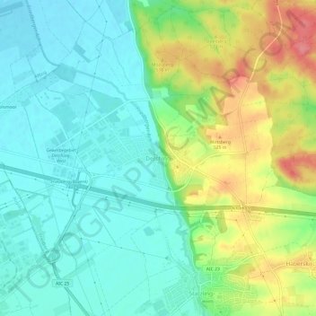
Name: Derching topographic map, elevation, terrain.
Average elevation: 1,601 ft
Minimum elevation: 1,512 ft
Maximum elevation: 1,778 ft
Make a donation
Gear up for your next adventure:
As an Amazon Associate, this site earns from qualifying purchases at no extra cost to you.
Other topographic maps
Click on a map to view its topography, its elevation and its terrain.
Friedberger Baggersee
Deutschland > Bayern > Landkreis Aichach-Friedberg > Friedberg
Average elevation: 1,591 ft
86316
Deutschland > Bayern > Landkreis Aichach-Friedberg > Friedberg > Wiffertshausen
Average elevation: 1,627 ft