
Make a donation
Gear up for your next adventure:
As an Amazon Associate, this site earns from qualifying purchases at no extra cost to you.
Brandywine Village topographic map
Click on the map to display elevation.
Make a donation
Gear up for your next adventure:
As an Amazon Associate, this site earns from qualifying purchases at no extra cost to you.
About this map
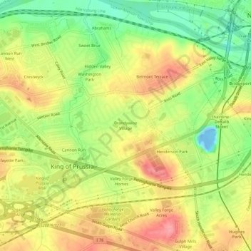
Name: Brandywine Village topographic map, elevation, terrain.
Average elevation: 164 ft
Minimum elevation: -69 ft
Maximum elevation: 312 ft
Make a donation
Gear up for your next adventure:
As an Amazon Associate, this site earns from qualifying purchases at no extra cost to you.
Other topographic maps
Click on a map to view its topography, its elevation and its terrain.
King of Prussia
United States > Pennsylvania > Montgomery County > Upper Merion Township > King of Prussia
Average elevation: 194 ft
Valley Forge National Historical Park
United States > Pennsylvania > Montgomery County > Upper Merion Township > King of Prussia
Average elevation: 174 ft
King of Prussia
United States > Pennsylvania > Montgomery County > Upper Merion Township
Average elevation: 194 ft