
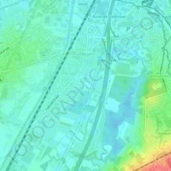
Ruisbroek topographic map
Interactive map
Click on the map to display elevation.
About this map
Name: Ruisbroek topographic map, elevation, terrain.
Average elevation: 95 ft
Minimum elevation: 52 ft
Maximum elevation: 259 ft
Other topographic maps
Click on a map to view its topography, its elevation and its terrain.
Oudenaken
België > Vlaams-Brabant > Halle-Vilvoorde > Sint-Pieters-Leeuw
Oudenaken, Sint-Pieters-Leeuw, Halle-Vilvoorde, Vlaams-Brabant, België
Average elevation: 135 ft
Sint-Pieters-Leeuw
België > Vlaams-Brabant > Halle-Vilvoorde > Sint-Pieters-Leeuw
Sint-Pieters-Leeuw, Halle-Vilvoorde, Vlaams-Brabant, 1600, België
Average elevation: 138 ft
Brukom
België > Vlaams-Brabant > Halle-Vilvoorde > Sint-Pieters-Leeuw
Brukom, Sint-Pieters-Leeuw, Halle-Vilvoorde, Vlaams-Brabant, Vlaanderen, 1651, België
Average elevation: 128 ft
Sobroek
België > Vlaams-Brabant > Halle-Vilvoorde > Sint-Pieters-Leeuw > Vlezenbeek
Sobroek, Vlezenbeek, Sint-Pieters-Leeuw, Halle-Vilvoorde, Vlaams-Brabant, Vlaanderen, 1602, België
Average elevation: 138 ft
Vlezenbeek
België > Vlaams-Brabant > Halle-Vilvoorde > Sint-Pieters-Leeuw
Vlezenbeek, Sint-Pieters-Leeuw, Halle-Vilvoorde, Vlaams-Brabant, 1602, België
Average elevation: 154 ft