
Make a donation
Gear up for your next adventure:
As an Amazon Associate, this site earns from qualifying purchases at no extra cost to you.
Pishin topographic map
Click on the map to display elevation.
Make a donation
Gear up for your next adventure:
As an Amazon Associate, this site earns from qualifying purchases at no extra cost to you.
Pishin
Pishin has an altitude of 219 metres (721 feet). It is near the Pakistani border, across which is the town of Mand to the east. The Iranian government has set up a customs post to develop border trade between Iran and Pakistan.
Make a donation
Gear up for your next adventure:
As an Amazon Associate, this site earns from qualifying purchases at no extra cost to you.
About this map
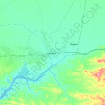
Name: Pishin topographic map, elevation, terrain.
Average elevation: 787 ft
Minimum elevation: 663 ft
Maximum elevation: 1,194 ft
Make a donation
Gear up for your next adventure:
As an Amazon Associate, this site earns from qualifying purchases at no extra cost to you.
Other topographic maps
Click on a map to view its topography, its elevation and its terrain.
دهستان پسکوه
Iran > Sistan and Baluchestan Province > Sib and Suran County
Average elevation: 4,528 ft
Make a donation
Gear up for your next adventure:
As an Amazon Associate, this site earns from qualifying purchases at no extra cost to you.