
Make a donation
Gear up for your next adventure:
As an Amazon Associate, this site earns from qualifying purchases at no extra cost to you.
La Zaidía topographic map
Click on the map to display elevation.
Make a donation
Gear up for your next adventure:
As an Amazon Associate, this site earns from qualifying purchases at no extra cost to you.
About this map
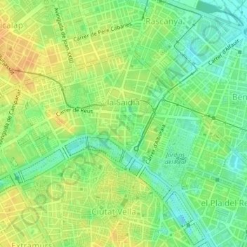
Name: La Zaidía topographic map, elevation, terrain.
Average elevation: 66 ft
Minimum elevation: 13 ft
Maximum elevation: 112 ft
Make a donation
Gear up for your next adventure:
As an Amazon Associate, this site earns from qualifying purchases at no extra cost to you.
Other topographic maps
Click on a map to view its topography, its elevation and its terrain.
Parque Natural de La Albufera
España > Comunidad Valenciana > Comarca de Valencia > Valencia > el Palmar
La albufera de Valencia es una laguna costera somera (profundidad media de 1 m) situada en la costa mediterránea al sur de la ciudad de Valencia. Ocupa una superficie de 23,94 km² y está rodeada de 223 km² de arrozales. Su cuenca hidrográfica se extiende por 917,1 km², desde el nivel del mar hasta una…
Average elevation: 46 ft
Parque de Cabecera
España > Comunidad Valenciana > Comarca de Valencia > Valencia
Average elevation: 89 ft
Paseo de Alfauir - Tramo IV
España > Comunidad Valenciana > Comarca de Valencia > Valencia
Average elevation: 43 ft
Horteta
España > Comunidad Valenciana > Comarca de Valencia > Valencia > Massarojos
Average elevation: 233 ft
Make a donation
Gear up for your next adventure:
As an Amazon Associate, this site earns from qualifying purchases at no extra cost to you.
Plaza de la Safor
España > Comunidad Valenciana > Comarca de Valencia > Valencia
Average elevation: 72 ft
Jardín de Alfredo Candell
España > Comunidad Valenciana > Comarca de Valencia > Valencia
Average elevation: 43 ft
Parque de Cabecera
España > Comunidad Valenciana > Comarca de Valencia > Valencia
Average elevation: 89 ft