
Make a donation
Gear up for your next adventure:
As an Amazon Associate, this site earns from qualifying purchases at no extra cost to you.
Kundagola topographic map
Click on the map to display elevation.
Make a donation
Gear up for your next adventure:
As an Amazon Associate, this site earns from qualifying purchases at no extra cost to you.
Kundagola
Kundgol is located at 15°15′N 75°15′E / 15.25°N 75.25°E / 15.25; 75.25. It has an average elevation of 615 metres (2017 feet).
Make a donation
Gear up for your next adventure:
As an Amazon Associate, this site earns from qualifying purchases at no extra cost to you.
About this map
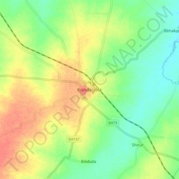
Name: Kundagola topographic map, elevation, terrain.
Location: Kundagola, Kundagola taluku, Dharwad, Karnataka, India (15.21651 75.20787 15.29651 75.28787)
Average elevation: 2,051 ft
Minimum elevation: 1,972 ft
Maximum elevation: 2,146 ft
Make a donation
Gear up for your next adventure:
As an Amazon Associate, this site earns from qualifying purchases at no extra cost to you.