
Aichwald topographic map
Click on the map to display elevation.
About this map
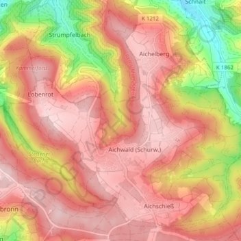
Name: Aichwald topographic map, elevation, terrain.
Location: Aichwald, Landkreis Esslingen, Baden-Württemberg, 73773, Germany (48.74372 9.34395 48.78827 9.41975)
Average elevation: 1,309 ft
Minimum elevation: 814 ft
Maximum elevation: 1,581 ft
Other topographic maps
Click on a map to view its topography, its elevation and its terrain.
Ruine Reußenstein
Germany > Baden-Württemberg > Landkreis Esslingen > Neidlingen
Average elevation: 2,215 ft
Bernhausen
Germany > Baden-Württemberg > Landkreis Esslingen > Filderstadt > Bernhausen
Average elevation: 1,253 ft