
Make a donation
Gear up for your next adventure:
As an Amazon Associate, this site earns from qualifying purchases at no extra cost to you.
Kupprichhausen topographic map
Click on the map to display elevation.
Make a donation
Gear up for your next adventure:
As an Amazon Associate, this site earns from qualifying purchases at no extra cost to you.
About this map
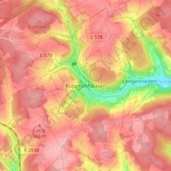
Name: Kupprichhausen topographic map, elevation, terrain.
Average elevation: 1,158 ft
Minimum elevation: 810 ft
Maximum elevation: 1,309 ft
Make a donation
Gear up for your next adventure:
As an Amazon Associate, this site earns from qualifying purchases at no extra cost to you.
Other topographic maps
Click on a map to view its topography, its elevation and its terrain.
97944
Deutschland > Baden-Württemberg > Main-Tauber-Kreis > Boxberg > Wölchingen
Average elevation: 1,125 ft
Windischbuch
Deutschland > Baden-Württemberg > Main-Tauber-Kreis > Boxberg
Average elevation: 1,161 ft
Lengenrieden
Deutschland > Baden-Württemberg > Main-Tauber-Kreis > Boxberg
Average elevation: 1,112 ft
Make a donation
Gear up for your next adventure:
As an Amazon Associate, this site earns from qualifying purchases at no extra cost to you.