
Make a donation
Gear up for your next adventure:
As an Amazon Associate, this site earns from qualifying purchases at no extra cost to you.
Lavaca topographic map
Click on the map to display elevation.
Make a donation
Gear up for your next adventure:
As an Amazon Associate, this site earns from qualifying purchases at no extra cost to you.
About this map
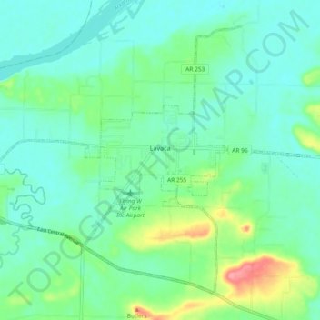
Name: Lavaca topographic map, elevation, terrain.
Location: Lavaca, Sebastian County, Arkansas, 72941, United States (35.30176 -94.22696 35.36495 -94.13476)
Average elevation: 440 ft
Minimum elevation: 367 ft
Maximum elevation: 659 ft
Sebastian County trails, hiking, mountain biking, running and outdoor activities
Make a donation
Gear up for your next adventure:
As an Amazon Associate, this site earns from qualifying purchases at no extra cost to you.
Other topographic maps
Click on a map to view its topography, its elevation and its terrain.
Saw Mill
United States > Arkansas > Sebastian County > Fort Smith > Saw Mill
Average elevation: 548 ft