
Sherbourne topographic map
Interactive map
Click on the map to display elevation.
About this map
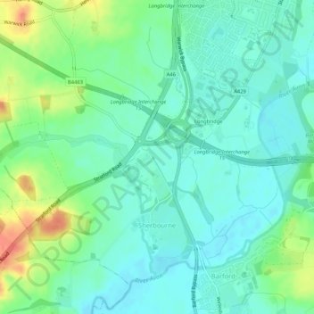
Name: Sherbourne topographic map, elevation, terrain.
Location: Sherbourne, Warwick, Warwickshire, England, United Kingdom (52.24441 -1.64776 52.27040 -1.59595)
Average elevation: 184 ft
Minimum elevation: 135 ft
Maximum elevation: 302 ft
Other topographic maps
Click on a map to view its topography, its elevation and its terrain.
Warwick Castle
United Kingdom > England > Warwickshire > Warwick
Warwick Castle, Northern Tower, Cliff Hill, Warwick, Warwickshire, England, CV34 4QX, United Kingdom
Average elevation: 184 ft
Leek Wootton
United Kingdom > England > Warwickshire > Warwick
Leek Wootton, Warwick, Warwickshire, England, CV35 7RS, United Kingdom
Average elevation: 249 ft
Warwick
United Kingdom > England > Warwickshire > Warwick
Warwick, Warwickshire, West Midlands, England, United Kingdom
Average elevation: 285 ft