
Thank you for supporting this site ❤️
Make a donation
Make a donation
Gear up for your next adventure:
As an Amazon Associate, this site earns from qualifying purchases at no extra cost to you.
Moc Chau topographic map
Click on the map to display elevation.
Thank you for supporting this site ❤️
Make a donation
Make a donation
Gear up for your next adventure:
As an Amazon Associate, this site earns from qualifying purchases at no extra cost to you.
About this map
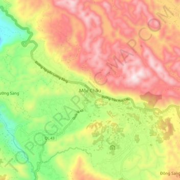
Name: Moc Chau topographic map, elevation, terrain.
Location: Moc Chau, Mộc Châu District, Sơn La Province, 34719, Vietnam (20.81436 104.57827 20.89436 104.65827)
Average elevation: 3,005 ft
Minimum elevation: 1,503 ft
Maximum elevation: 4,403 ft
Thank you for supporting this site ❤️
Make a donation
Make a donation
Gear up for your next adventure:
As an Amazon Associate, this site earns from qualifying purchases at no extra cost to you.