
Make a donation
Gear up for your next adventure:
As an Amazon Associate, this site earns from qualifying purchases at no extra cost to you.
Libeek topographic map
Click on the map to display elevation.
Make a donation
Gear up for your next adventure:
As an Amazon Associate, this site earns from qualifying purchases at no extra cost to you.
Libeek
Libeek (Limburgs: Liebik) is een buurtschap bij Sint Geertruid in de gemeente Eijsden-Margraten. Tot 31 december 2010 maakte de buurtschap deel uit van de gemeente Margraten. De plaats is in de 13e eeuw gesticht. Libeek ligt op ongeveer 130 m hoogte. Zo'n kilometer ten zuiden van Libeek ligt het Hoogbos.
Make a donation
Gear up for your next adventure:
As an Amazon Associate, this site earns from qualifying purchases at no extra cost to you.
About this map
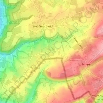
Name: Libeek topographic map, elevation, terrain.
Average elevation: 443 ft
Minimum elevation: 230 ft
Maximum elevation: 604 ft
Make a donation
Gear up for your next adventure:
As an Amazon Associate, this site earns from qualifying purchases at no extra cost to you.